Current Weather Outlook
Statewide weather outlook from Florida Division of Emergency Management MeteorologyTuesday, May 7, 2024
...Lingering Foggy Conditions Will Linger Through Mid-Morning Hours Along Panhandle and Big Bend This Morning...High Pressure Building Over Gulf of Mexico To Bring Mostly Sunny and Dry Conditions Through Afternoon...Isoalted to Scattered Showers and Thunderstorms Along Sea Breeze Boundaries Later in the Afternoon and Evening...High Temperatures Buildings Thorughout Day Reaching Upper 80s to Middle 90s...Lingering Showers Thorugh Early Overnight Hours As Activity Dissipates...Foggy Conditions and Low Clouds From Panhandle to Nature Coast Overnight and Early Wednesday Morning...Moderate to High Risk for Rip Currents for All Panhandle and East Coast Beaches...
Updated at 9:43 AM EDT
Today's Threats:
| No Threat | Low Threat | Medium Threat | High Threat |
| Lightning | Damaging Wind/Hail | Tornado | Excessive Heat | Fog (Overnight) | Wildfire | River Flooding | Rip Currents |
|
Locally Interior Peninsula |
Locally Iso. Inteiror Peninsula |
Locally Int. Panahndle and I-75 Corridor |
Locally Panhandle & Nature Coast Northeast Florida |
West-Central & Interior Peninsula |
Santa Fe River at Three Rivers Estates |
Panhandle & Southeast Florida Northeast & East Central Florida West Coast |
![]()
Weather Summary for the Next 24 Hours:
Lingering dense fog and low clouds this morning has prompted a Dense Fog Advisory along the Panhandle and Big Bend through the mid-morning hours due to reduced visibility of ¼ of a mile or less at times. High pressure will build over the Gulf of Mexico today, bringing mostly sunny and dry conditions across the state through the afternoon hours. High temperatures will climb well into the upper 80s and middle 90s statewide this afternoon, with coastal areas a few degrees cooler with sea breeze winds flowing onshore. Temperatures during the early to middle afternoon hours will feel-like they are in the middle 90s and approaching the upper 90s in some locations across the interior Panhandle and Central Florida. The Gulf and Atlantic sea breeze boundaries will push inland throughout the day before colliding with one another this evening, sparking isolated to widely scattered showers and possible thunderstorms (20-30% chance of rain). These showers and thunderstorms will be mostly concentrated throughout the interior and towards the eastern Peninsula this evening. Organized severe weather is not expected with thunderstorm activity; however, locally strong to possibly severe thunderstorms cannot be ruled out during the peak heating hours of the evening. Any strong thunderstorm activity that develops will be capable of producing frequent lightning, gusty winds and heavy downpours at times.

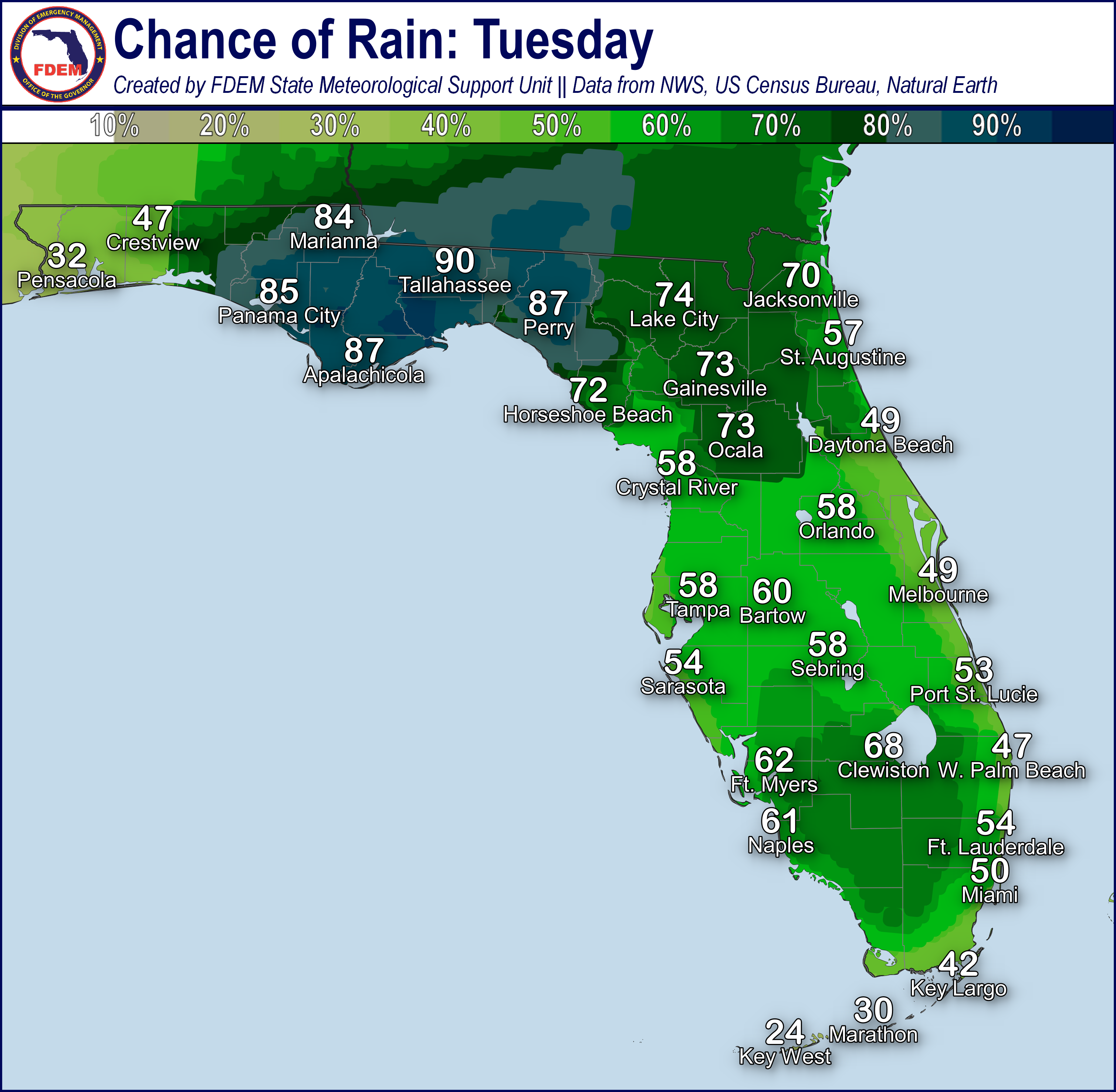
Shower and thunderstorm activity will linger throughout the evening and into the early overnight hours before dissipating as they move towards the coastlines (15-20% chance of rain). Very isolated showers may linger along the coastlines through the overnight hours as they attempt to move over adjacent coastal waters. Calm winds and clear skies developing overnight and early Wednesday morning will give way to patchy to locally dense fog developing from the Panhandle, across the Suwannee Valley and into Nature Coast. Low temperatures will only fall into the upper 60s to middle 70s, with the Keys seeing low temperatures in the upper 70s allowing for little relief from daytime high temperatures.

![]()

Rip Currents: Persistent and breezy onshore winds will continue along Panhandle and East Coast beaches creating a moderate to high risk for rip currents. A low risk for rip currents continues for West Coast beaches. For the latest Rip Current Outlook, visit www.weather.gov/beach.
Marine Hazards: Southerly to southeasterly winds flowing onshore will create wave heights of 1-3’ statewide. Breaking waves further offshore from Atlantic-facing Key beaches will reach upwards of 4’ throughout the day.
Red Tide has not been observed at or above background levels over the past week.
Coastal Flooding: There is no risk of coastal flooding today.
![]()
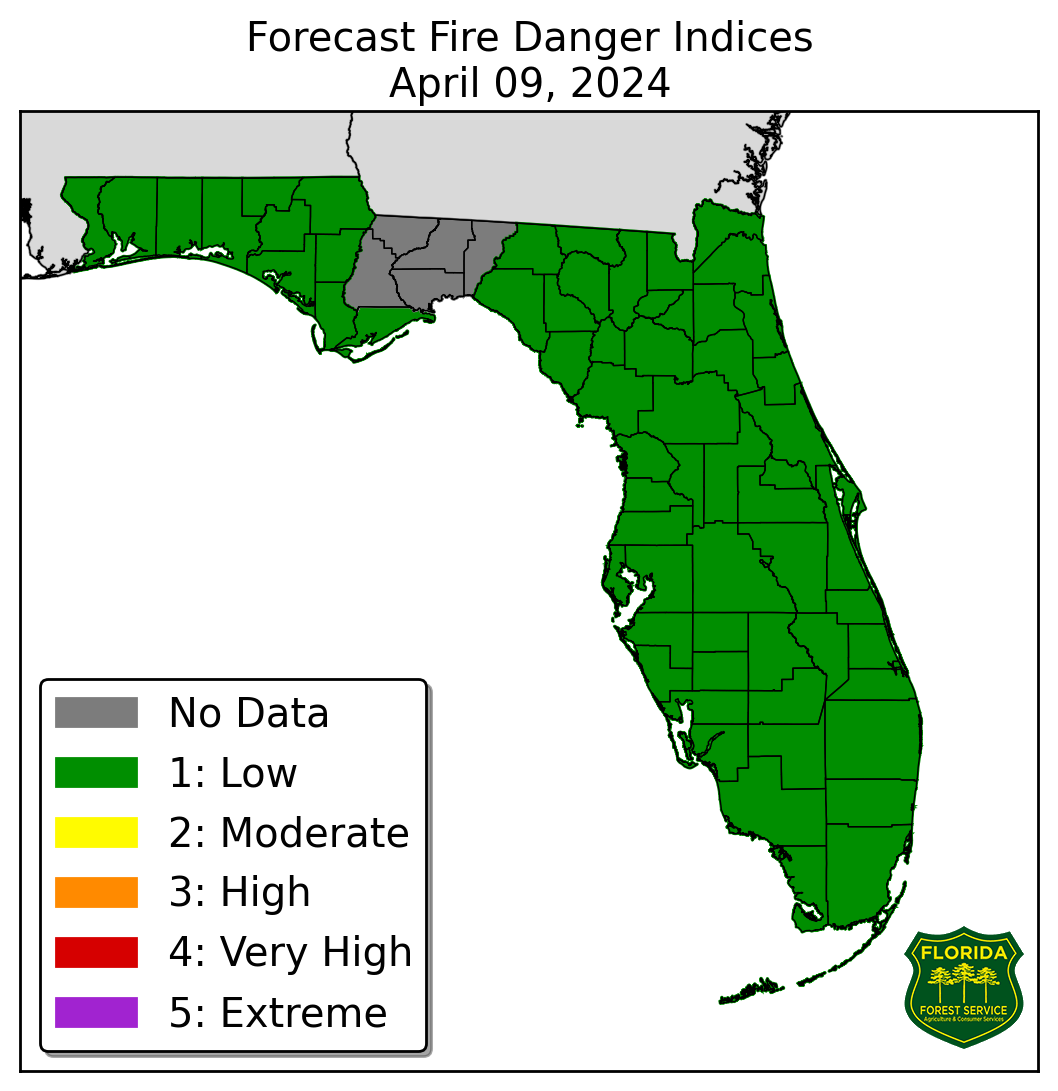
Fire Weather: Areas of dense fog and low clouds across the Panhandle and Suwannee Valley will continue through the mid-morning hours before lifting and dissipating. Foggy conditions may reduce visibility further where there are ongoing wildfires. Mostly dry conditions will persist through the afternoon statewide before the sea breeze collision this afternoon across the Peninsula allows for isolated to widely scattered showers and possible thunderstorms this evening. Warm and dry conditions will develop statewide as high pressure builds and dominates. Ongoing warm and dry conditions will keep sensitive wildfire conditions in place across portions of Central and South Florida, especially where there is emerging to moderate drought conditions. Wind gusts will remain near 10-15 mph, but the sea breeze along the coasts may create locally breezy wind gusts upwards of 20 mph at times. Any thunderstorm that develops this afternoon will be capable of producing lightning and gusty winds, which could contribute to igniting or spreading wildfires over dry grounds and soils. Patchy to locally dense fog will be possible overnight and early Wednesday morning from the Panhandle to Nature Coast. According to the Florida Forest Service, there are 51 active wildfires across the state burning approximately 1200 acres.

Drought: High pressure has continued to yield relatively dry conditions and near to above normal temperatures statewide over the last week, leading to high evaporative demand and locally decreasing streamflow. Several recent brush fires have been noted and there has been an increased concern for more as short-term dryness and drought continue. Abnormally dry (emerging drought) conditions have expanded along further northward and southward across Central and Southern portions of the Peninsula on this week’s drought monitor update and now stretch from the from the I-4 and south to the I-75 and from the West to the East Coast. Moderate Drought conditions have been introduced to eastern portions of the region from Brevard County to Palm Beach County and surrounding Lake Okeechobee as rainfall deficits continue to increase. Above normal temperatures and below normal rainfall expected across the region over the next week will likely exacerbate drought conditions.
The Keetch-Byram Drought Index average for Florida is 359 (+7) on a scale from 0 (very wet) to 800 (very dry). There are five Florida counties (Brevard, Highlands, Indian River, Sarasota and St. Lucie) with an average KBDI over 500 (drought/increased fire danger).
![]()
Flash Flooding: There is no organized risk for flash flooding today. Showers and possible thunderstorms developing along the sea breeze boundaries this evening throughout the interior Peninsula. Any strong thunderstorm that is able to develop will be capable of producing heavy downpours which could lead to instances of localized flooding and ponding of water across urban and low-lying/poor drainage areas. While rainfall totals are forecast to remain below 0.5”, isolated totals locally of 1-2” cannot be ruled out within heavy downpours. Slow-moving or near stationary showers and thunderstorms may also increase the localized potential for flooding as downpours may lead to accumulated water.

Riverine Flooding: A River Flood Warning remains in effect along the Santa Fe River at Three Rivers Estates as minor flooding is occurring and is forecast to continue through the end of this week. Portions of several Big Bend and Suwannee Valley rivers (including several portions of the Suwannee River) remain in Action Stage (bank-full); however, water levels are continuing to fall. There are no additions riverine flood concerns at this time. For more details, please visit the River Forecast Center.
Lake Okeechobee’s average elevation is 14.02 feet, which is within the operational band and 0.54 feet above normal for this time of year.
