RSS 5 Day Weather Outlook
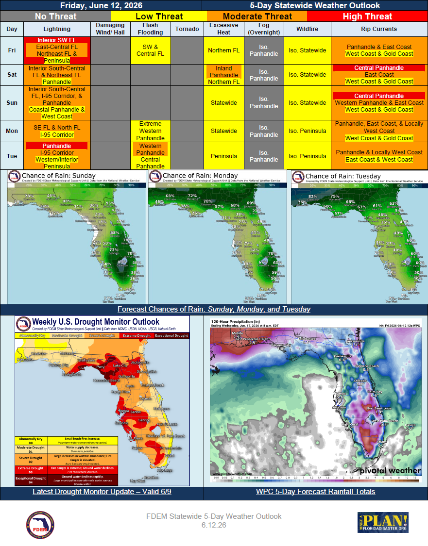
5 Day Statewide Weather Outlook for Fri. 6/12 to Tue. 6/16
You are subscribed to 5 Day Weather Outlook for Florida Division of Emergency Management. This information has recently been updated, and is now available.
…Hottest Temperatures of the Summer So Far Expected This Weekend… Widespread Heat Indexes Will Approach or Exceed 105F… Many Locations Across North Florida May Need Heat Advisories… Typical Summer Showers and Storms Expected Across Inland Peninsula Areas Through Sunday… Cold Front Approaches Early Next Week… Heavy Rainfall to Spread Across North Florida With Cold Front… Numerous Days Highlighted for Excessive Rainfall Through Tuesday… Localized High Risk for Rip Currents Across Panhandle this Weekend… Moderate to Low Risk of Rip Currents for all Other Beaches… Sensitive Wildfire Conditions to Continue Despite Rainfall…
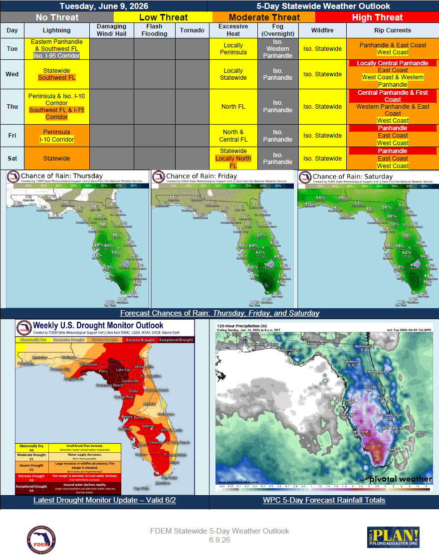
5 Day Statewide Weather Outlook for Tue. 6/9 to Sat. 6/13
You are subscribed to 5 Day Weather Outlook for Florida Division of Emergency Management. This information has recently been updated, and is now available.
…Return to Summer-Like Conditions Expected this Week with Increasing Moisture/Rain Chances and Heat/Humidity… Chances for Rain Initially Favor Southern Florida Over First Half of Week… Rain Chances Spread Northward With Each Day… Scattered to Widespread Showers and Storms Expected Statewide by Weekend… Hottest Feels-Like Temperatures of the Summer Thus Far Expected This Weekend… Widespread Triple-Digit Feels-Like Temperatures Expected End of Week… Some Locations May Reach or Exceed 105F on Saturday… High Risk of Rip Currents Expected Across Panhandle this Week… Moderate Risk for all East Coast Beaches… Sensitive Wildfire Conditions to Continue Despite Rainfall…
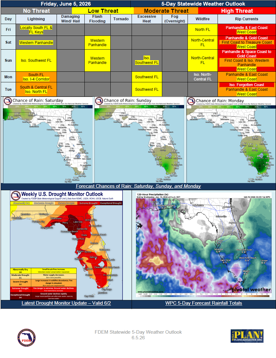
5 Day Statewide Weather Outlook for Fri. 6/5 to Tue 6/9
You are subscribed to 5 Day Weather Outlook for Florida Division of Emergency Management. This information has recently been updated, and is now available.
…Hot and Dry Conditions Expected Over the State as High Pressure Settles in… Minimal Rain Chances Expected Outside of South Florida and Extreme Western Panhandle Through Saturday… Marginal Risk for Flash Flooding Saturday and Sunday in Escambia/Santa Rosa Counties as Gulf Low Spreads moisture Over Central Gulf Coast… High Pressure Shifts Eastward on Sunday, Allows Moisture to Begin Spreading Northward… Rain Chances Increase in South Florida on Sunday and Spread Northward With Each Day… Sensitive Fire Weather Conditions Likely Through Sunday Across North Florida… Hot and Muggy Summer-Like Conditions Return Statewide By Early Next Week… High Risk of Rip Currents Expected for All East Coast and Panhandle Beaches Friday and Saturday… Rip Current Risk Declines with Each Day After as Onshore Flow Eases…
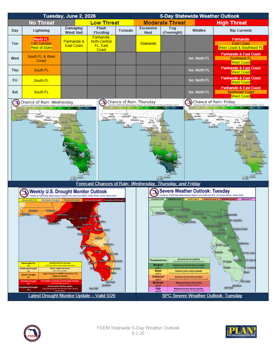
5 Day Statewide Weather Outlook for Tue. 6/2 to Sat. 6/6
You are subscribed to 5 Day Weather Outlook for Florida Division of Emergency Management. This information has recently been updated, and is now available.
…Cold Front Sweeps Through the State in the First Half of the Week… Widespread Showers and Thunderstorms Expected Along Northern and Eastern Florida Today Associated with Front… Some of Today’s Storms may be Strong to Severe… Isolated Damaging Wind Gusts the Primary Concern… Marginal Risk for Flash Flooding Over Northern and Eastern Florida Today… Rain Chances Shift to South Florida Mid-Week as Front Slides Southward… Cooler and Drier Air Filters in Behind the Front… High Risk for Rip Currents Expected for Panhandle and East Coast Beaches All Week…
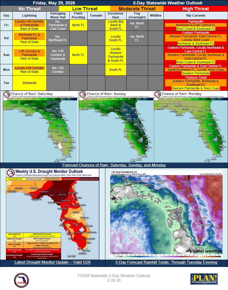
5 Day Statewide Weather Outlook for Fri. 5/29 to Tue. 6/2
You are subscribed to 5 Day Weather Outlook for Florida Division of Emergency Management. This information has recently been updated, and is now available.
…More Beneficial Rainfall Expected for Much of the State Through Early Next Week… Chances for Rain will Favor Inland Panhandle Regions and the I-95 Corridor Through Sunday… Cold Front Approaches on Sunday and Slowly Moves Southward Through Tuesday… Rain Chances Decline in North Florida Following Frontal Passage… Isolated Flash Flooding Possible in North Florida on Friday and Sunday… Hot and Muggy Conditions Expected Statewide This Week… Afternoon Feels-Like Temperatures May Exceed 100 Degrees in Isolated Locations… Dangerous Rip Currents Expected for Various Coastal Locations Throughout the Week…