Current Weather Outlook
Statewide weather outlook from Florida Division of Emergency Management Meteorology
Tuesday, June 23, 2026
... Scattered Showers and Storms Along the I-10 Corridor This Afternoon; Isolated Activity Across the Peninsula... Any Storms will be Accompanied by Lightning, Gusty Winds, and Torrential Downpours... Highs in the 90s Statewide... Heat Indices in the Middle to Upper 100s Across the Peninsula; Heat Advisories in Effect for Southeast Metro... Moderate to High Risk of Rip Currents Across Panhandle Beaches...Low Risk of Rip Currents Elsewhere...
Updated at 8:17 AM EDT
Today's Threats:
|
No Threat |
Low Threat |
Medium Threat |
High Threat |
|
Lightning |
Tornado |
Damaging Wind/Hail |
Wildfire |
Excessive Heat |
Flash Flooding |
Fog (Overnight) |
Rip Currents |
|
I-10 Corridor Statewide
|
|
Iso. I-10 & I-95 Corridor |
Iso. West-Central FL |
Peninsula Statewide |
|
|
Panhandle Rest of Florida |
![]()
Weather Summary for the Next 24 Hours:
A warm but clear start to the day throughout the Sunshine State will give way to isolated to scattered showers and thunderstorms later today. A cold front sagging southward into the Deep South will provide additional lift, in tandem with the sea breezes, for shower and thunderstorm development along the I-10 corridor this afternoon (40-60% chance of rain), some of which may become locally strong to severe. The primary hazards with any thunderstorms will be frequent lightning, locally damaging wind gusts (40-60 mph), and torrential downpours. West to southwesterly winds will also increase ahead of this front across Northeast Florida, gusting upwards of 20-25 mph at times.
Throughout the Peninsula, high pressure with pockets of Saharan air will filter drier air across the area today, limiting the overall thunderstorm coverage. However, a few isolated storms will be possible across East-Central Florida and interior South Florida, some of which could become locally strong (25-40% chance of rain). Storms will be slow-moving throughout the Peninsula, which may lead to nuisance flooding and ponding of water in urban and poor drainage locations.
High temperatures will soar again into the upper 80s to middle 90s statewide this afternoon. Heat indices will peak in the middle to upper 100s throughout the Peninsula and a Heat Advisory is in effect for the Southeast Metro until 6 PM EDT.

Tonight, any lingering showers and thunderstorms across Northeast Florida and the I-95 corridor will dissipate or push offshore after dusk (25-40% chance of rain). Lows will fall into the 70s to lower 80s statewide.

![]()

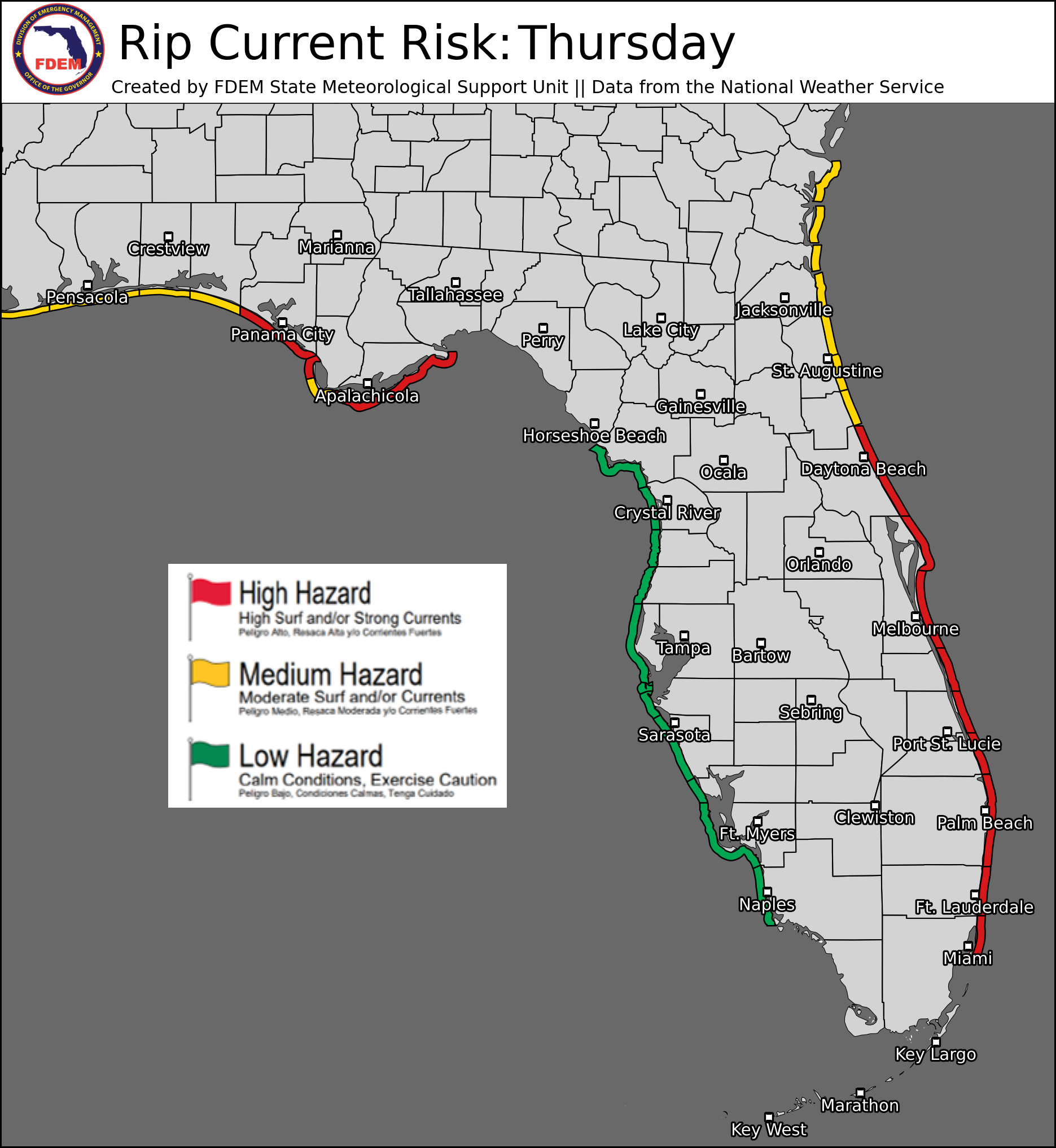
Rip Currents: A moderate to high risk for rip currents is in effect for all Panhandle beaches today. A low risk persists for all other beaches statewide. For the latest Rip Current Outlook, visit www.weather.gov/beach.
Marine Hazards: Surf will increase slightly along Panhandle shorelines today, with waves near 3-4’ this afternoon. Surf will remain near 1-3’ for all other statewide beaches.
Red Tide: was observed at background concentrations offshore Pinellas and Hillsborough counties over the past week. It was not observed elsewhere across the state (valid 6/19/26).
Coastal Flooding: There are no current coastal flood alerts for the state.
![]()
Fire Weather: Scattered showers and thunderstorms will spread across the I-10 corridor later this afternoon as a frontal boundary interacts with the sea breezes. Throughout the Peninsula, thunderstorm coverage will be more limited today with pockets of Saharan dust filtering into the atmosphere. However, isolated to widely scattered activity will initiate along the I-95 corridor and interior South Florida today. Any thunderstorm could be accompanied by lightning and gusty/erratic winds, which can spark new wildfires or reignite existing ones. Much drier conditions have developed locally over West-Central Florida where a predominate westerly flow has kept thunderstorm activity off to the east. As such, locally sensitive wildfire conditions have developed here amidst ongoing extreme drought (level 3 of 4). According to the Florida Forest Service, there are 62 active wildfires across the state burning approximately 28,970 acres.
Drought (6/16/26): Very little to no changes were made to the drought across North Florida on this week’s update, with many areas keeping their drought category from last week’s update. Exceptional drought (level 4 of 4) remains across localized portions of the coastal Big Bend and Suwannee River Valley, with extreme drought (level 3 of 4) surrounding that. Throughout Central and South Florida, some reductions in the drought were observed across West-Central and interior South Florida. Some of the extreme drought (level 3 of 4) in these areas has been reduced to a severe drought (level 2 of 4), including in Collier, Hendry, Monroe, Miami-Dade, Charlotte, and Lee counties. Coastal areas of Collier and mainland Monroe counties is now under a moderate drought (level 1 of 4). Some heavy rainfall along the I-95 corridor has brought moderate drought conditions down to abnormally dry (emerging drought) conditions in Brevard, Indian River, and St. Lucie counties. All other remaining drought areas saw little to no change in this week’s update. Recent flash flooding over North Florida will likely promote more substantial drought improvements across these areas in next week’s update, with more seasonable distributions of showers and storms across the Peninsula likely providing some localized categorical improvements. Limited observed rainfall across the Western half of the peninsula will likely lead to degradations in the drought conditions.

The Keetch-Byram Drought Index average for Florida is 319 (-19) on a scale from 0 (very wet) to 800 (very dry). There are 9 out of 67 Florida counties that have an average KBDI above 500 (drought/increased fire danger).

![]()
Flash Flooding: There is no organized risk for flash flooding today. Scattered thunderstorms will develop along and near the I-10 corridor later this afternoon, some of which may be locally strong to severe and accompanied by torrential downpours. Isolated storms are also expected along the I-95 corridor and interior South Florida. Areas of nuisance flooding and ponding of water cannot be ruled out in urban and poor drainage areas that receive the heaviest rainfall. Rainfall totals will generally remain below 1” for most locations, however locally higher totals upwards of 2-3” cannot be ruled out.

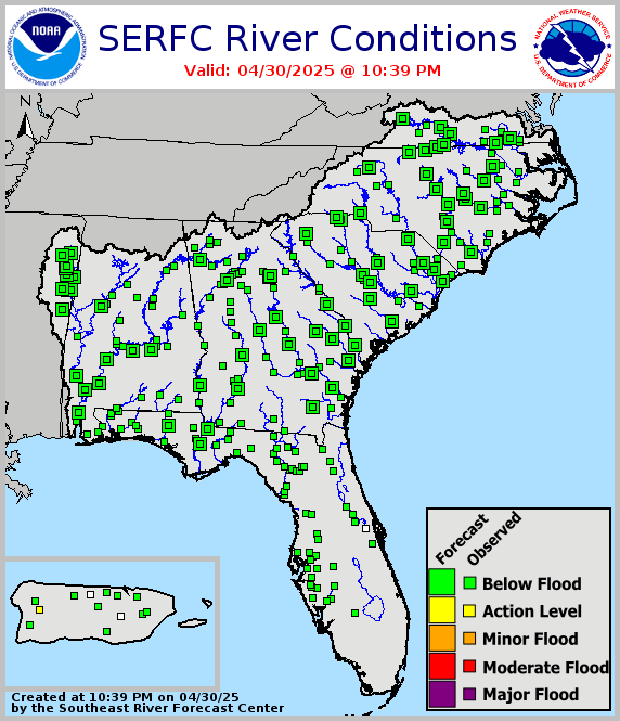
Riverine Flooding: Flash flooding over the past few days has prompted riverine responses across the Florida Panhandle. The following gauges are expected to reach or are currently in minor flood stage: Escambia River near Century, Blackwater River near Baker , Shoal River near Crestview, and the Choctawatchee River near Bruce-Ebro. Numerous other gauges are in or forecast to reach Action Stage (bank-full). River Flood Warnings remain in effect for the Escambia River, Blackwater River, Shoal River, and Choctawhatchee River. For more information, visit the River Forecast Center.
Lake Okeechobee’s average elevation is 11.00 feet, which is within the operational band and is 2.24 feet below normal for this time of year.