RSS 5 Day Weather Outlook
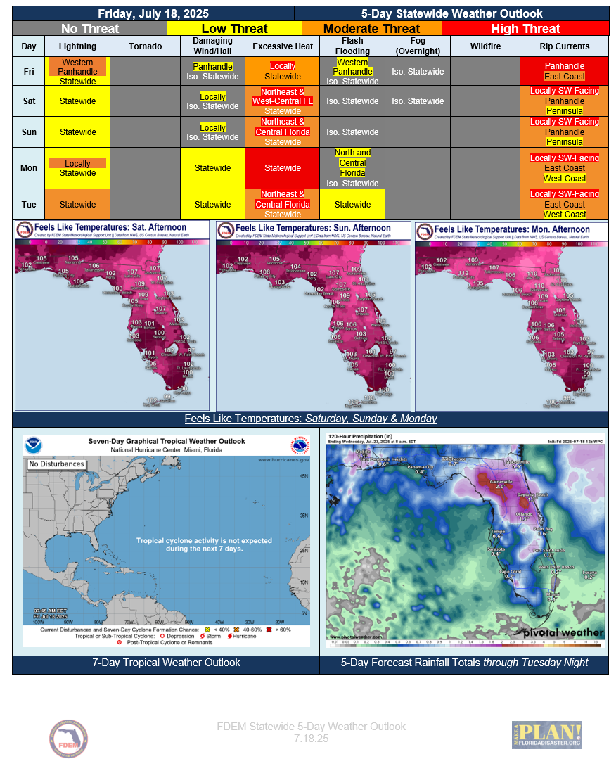
5 Day Statewide Weather Outlook (Fri. 7-18-25 To Tue. 7-22-25)
You are subscribed to 5 Day Weather Outlook for Florida Division of Emergency Management. This information has recently been updated, and is now available.
Deep Southerly Flow Remains on Friday Bringing Some Rain Chances Statewide and High Rip Current Risk Along the Gulf Coast…Slight Risk for Flash Flooding Over Far Western Florida Panhandle With Greatest Rain Chance… Embedded Thunderstorms Could Produce Localized Flooding for Urban and Low-lying Poor Drainage Areas…Rain Chances Become Isolated Across the State This Weekend…Afternoon High Temperatures Reach Mid-90s to Low 100s Statewide...Feels-like Temperatures Reach Heat Advisory Criteria Over Central and North Florida... Greater Rain Chances Return Monday and Tuesday with an Approaching Upper-Level Disturbance from the East… Flash Flood Concerns Return Early Next Week…
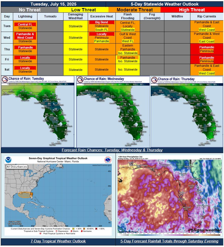
5 Day Statewide Weather Outlook for Tue. 7/15 to Sat. 7/19
You are subscribed to 5 Day Weather Outlook for Florida Division of Emergency Management. This information has recently been updated, and is now available.
…Invest 93L Expected to Bring Plenty of Rainfall Statewide… Flood Watch Issued for Central Florida Through Tuesday Evening…Minor Riverine Flooding Possible for Quick-Response Rivers Along West-Central Florida Depending on Heavy Rainfall…Marginal and Slight Risk of Flash Flooding Throughout the State Tuesday…Marginal Risk Continues Along Panhandle and West Coast Through Midweek… Florida Panhandle Expecting Widespread Rainfall on Wednesday and Thursday…More Organized Thunderstorms Could Produce Localized Flooding for Urban and Low-lying Poor Drainage Areas…Strong Rip Currents Throughout The Gulf Coast till the Start Of The Weekend…Heat Index Values Reach Above Triple Digits For The Florida Panhandle…
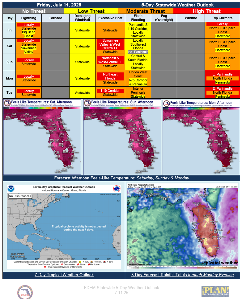
5 Day Statewide Weather Outlook (Fri. 7/11 - Tue. 7/15)
You are subscribed to 5 Day Weather Outlook for Florida Division of Emergency Management. This information has recently been updated, and is now available.
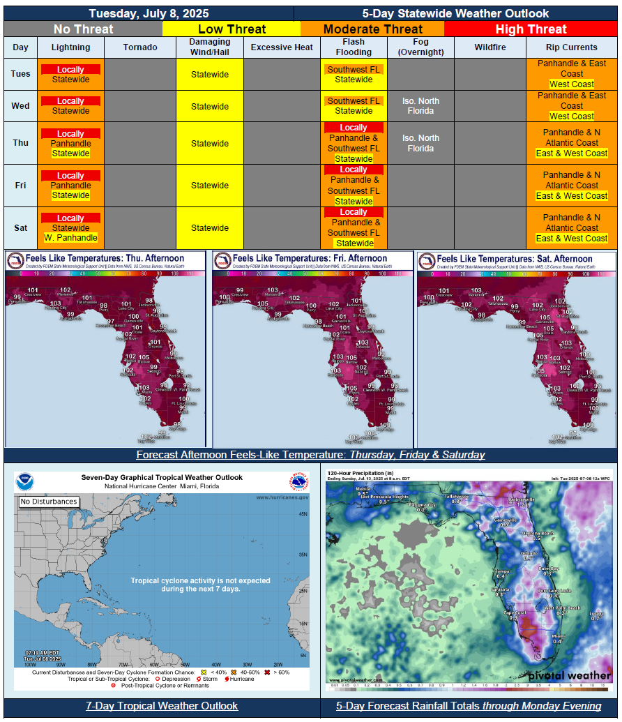
5 Day Statewide Weather Outlook for Tue. 7/8 to Sat. 7/12
You are subscribed to 5 Day Weather Outlook for Florida Division of Emergency Management. This information has recently been updated, and is now available.
…Heat Index Values in Tripple Digits Statewide Approaching Heat Advisory Criteria…Summertime Sea Breeze Showers Each Day…More Organized Thunderstorms Could Produce Localized Flooding for Urban and Low-lying Poor Drainage Areas…Marine Conditions Remain Calm…Areas of Patchy Fog Possible Later in the Week…. Improvements Occurred with Recent Drought Monitor Update…Tropical Cyclone Formation is Not Expected in the Next 7 Days…
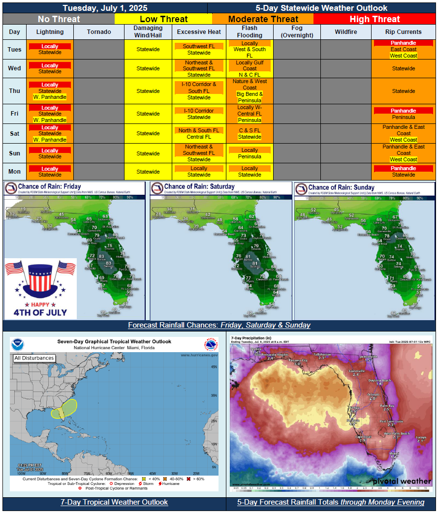
5 Day Statewide Weather Outlook for Tue. 7/1 to Mon. 7/7
You are subscribed to 5 Day Weather Outlook for Florida Division of Emergency Management. This information has recently been updated, and is now available.
…Wet and Unsettled Pattern Across the State For Next Several Days…Scattered to Numerous to Numerous Showers and Thunderstorms Each Day…Weak Frontal Boundary to Aid Daily Thunderstorm Development…Increased Risk for Flash Flooding With Heavy Downpours and Repeated Rounds of Rainfall…Embedded Strong to Severe Thunderstorms Possible…Low (30%) Chance for Area of Weak Low Pressure to Develop Along Stalling Frontal Boundary Weekend; High Uncertainty and Low Confidence…Seasonable Temperatures and Heat Index Values; Values in Triple Digits Possible for Portions of State…